The map of Maldives reveals a breathtaking archipelago in the Indian Ocean, renowned for its pristine beaches, luxurious resorts, and rich marine biodiversity. Comprising over 1,190 coral islands grouped into 26 natural atolls, the Maldives map is essential for travellers seeking to explore this paradise. This guide provides an in-depth look at the geography of the Maldives, key islands, travel routes, and conservation efforts.
Why the Maldives Captivates Travellers
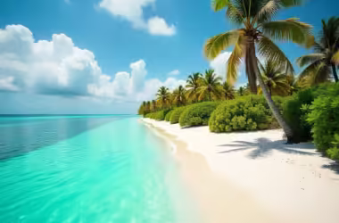
So, what makes the Maldives such a sought-after tropical escape? For starters, its stunning spread of 26 atolls and over a thousand islands, all set like shimmering gems in the heart of the Indian Ocean, instantly conjure visions of endless white sands and postcard-perfect turquoise waters. Thanks to its equatorial location, sunshine graces these islands year-round, inviting sun worshippers and adventure seekers without pause for seasons.
What truly sets the Maldives apart, though, is the richness beneath the surface—quite literally. The islands are celebrated for their thriving coral reefs teeming with vibrant marine life. Scuba divers and snorkelers come from across the globe for a glimpse of manta rays, whale sharks, and rainbow-hued fish set against coral gardens that rival the world’s finest. No wonder it’s a bucket-list destination for anyone who loves the sea.
Of course, it isn’t just about underwater wonders. Whether you’re seeking mellow beach days, world-class water sports, or a tranquil retreat surrounded by swaying palms, the Maldives delivers with a blend of natural beauty and inviting warmth. There’s a reason this archipelago holds a special spot on travel wish lists everywhere.
Overview of the Map of Maldives
The Map of Maldives showcases an archipelago located southwest of Sri Lanka and India. Spanning approximately 90,000 square kilometers, the Maldives consists of coral atolls that sit atop an underwater mountain range. With over 200 inhabited islands and more than 150 resort islands, understanding the Maldives atoll map helps tourists plan their journeys efficiently.
Latitude and Longitude of the Maldives
Geographically, the Maldives is positioned just south of the equator, straddling latitudes from roughly 7° north to just below 1° south, and longitudes between 72° and 74° east. These coordinates situate the nation amid the tranquil waters of the Indian Ocean, giving it its famously warm, tropical climate and making it a prime destination for sun-seekers.
Total Area of the Maldives
The Maldives covers an impressive total area of about 118,000 square kilometers. However, only a tiny fraction of this — roughly 298 square kilometers — is actual land, with the rest consisting of crystal-clear lagoons and vibrant coral reefs.
Land Area and Exclusive Economic Zone
The Maldives may span an impressive sweep of the Indian Ocean, but its actual land area remains quite modest—just about 298 square kilometers. In contrast, the nation boasts a vast Exclusive Economic Zone (EEZ), stretching across approximately 359,000 square kilometers of turquoise waters teeming with marine life. This disparity between land and ocean highlights why the Maldives is as renowned for its emerald-green islands as it is for the open sea that surrounds them.
Geographic Coordinates of the Maldives
Situated just north of the equator, the Maldives stretches between approximately 7° north and slightly less than 1° south latitude, and lies between 72° and 74° east longitude. This prime location gives the islands their warm, tropical climate and places them squarely in the heart of the Indian Ocean, making them an inviting destination for travelers seeking sun, sand, and sea.
Key Geographic Features
- Atolls and Reefs: The Maldives atolls map illustrates how these formations protect the islands from oceanic currents and create calm lagoons.
How Were the Atolls of the Maldives Formed?
The origins of the Maldives atolls are as fascinating as the islands themselves. Millions of years ago, ancient volcanic islands emerged from the Indian Ocean. Over time, these islands slowly subsided beneath the waves. As the land sank, colonies of coral flourished in the shallow waters above, building massive reefs that eventually formed the iconic ring-shaped atoll structures we see today. This remarkable process, first explained by Charles Darwin during his explorations, is what gives the Maldives its signature geography—perfectly circular atolls encircling turquoise lagoons.
The Significance of Coral Reefs in the Maldives
Coral reefs play a foundational role in shaping the Maldives, both above and below the waterline. These living structures, built up over millennia by countless generations of tiny marine creatures, are more than just scenic wonders—they’re crucial for the islands’ very existence. By forming the backbone of the atolls, coral reefs protect the low-lying islands from powerful ocean swells, acting as natural barriers that create tranquil lagoons and ensure calmer beaches for visitors and locals alike.
Beyond their protective function, coral reefs support one of the world’s richest marine ecosystems. Snorkelers and divers are drawn to the vibrant underwater life—including colorful tropical fish, graceful sea turtles, and curious reef sharks—that makes the Maldives a bucket-list destination for ocean enthusiasts. This biodiversity isn’t just a visual feast; it sustains traditional fishing practices and bolsters the local economy through tourism. In essence, without healthy coral reefs, the Maldives’ landscapes, livelihoods, and legendary beauty would be dramatically altered.
Marine Life Around Maldivian Coral Reefs
The coral reefs of the Maldives teem with vibrant marine life, making them a top destination for snorkelers and divers. Visitors can expect to encounter a kaleidoscope of tropical fish—from colourful parrotfish and angelfish to graceful butterflyfish. Larger residents like reef sharks and rays are commonly seen gliding through the clear waters, while sea turtles frequently nest and feed around the islands. These biodiverse ecosystems also play host to moray eels, groupers, and—if you’re lucky—a majestic manta ray or whale shark passing by.
Origin and Formation of the Maldives’ Atolls and Islands
The Maldives is the result of a fascinating geological process that spans millions of years. These islands are made up almost entirely of coral sand and limestone, the remnants of countless generations of marine organisms. But how did such an extraordinary collection of atolls take shape?
It all began with ancient volcanic activity deep beneath the Indian Ocean. Over time, these volcanoes slowly sank back beneath the sea, leaving behind submerged peaks. Coral polyps then got to work, gradually building massive reefs on top of these sunken volcanic bases. As each volcanic island disappeared below the waves, what remained were ring-shaped coral atolls surrounding central lagoons—a signature feature still visible on any map of the Maldives.
This ongoing natural process means the islands are in a constant state of change. Wind, waves, and ocean currents continually sculpt their shorelines, while the flourishing reefs support vibrant ecosystems teeming with tropical fish, sea turtles, and even the occasional reef shark.
- Coral Islands: The islands are made of coral sand and limestone, making them vulnerable to erosion and sea-level rise.
- Climate and Weather: The Maldives experiences a tropical monsoon climate, with warm temperatures year-round and distinct wet and dry seasons.
- Average Temperature in the Maldives: The Maldives enjoys pleasantly warm weather throughout the year. Daytime temperatures typically range from 29°C to 32°C (84°F to 90°F), making it an ideal destination for sunseekers and beach lovers alike.
Vibrant Marine Life Around the Reefs
Encircling each island, the vibrant coral reefs act as underwater metropolises—with a cast of marine residents that thrill snorkelers and divers alike. Here, you’ll encounter clouds of colorful reef fish darting among branching corals, while graceful sea turtles glide by in search of sponge snacks.
For those with a keen eye, Maldives’ reefs also offer glimpses of elegant manta rays, reef sharks weaving silently through the blue, and an impressive parade of parrotfish, angelfish, and butterflyfish. Dolphin pods are a frequent sight in the deeper channels, adding another layer of wonder to the region’s rich underwater tableau.
How Geography Shapes Maldivian Culture and Daily Life
The Maldives’ unique geography—a chain of coral islands and atolls adrift in the Indian Ocean—shapes nearly every aspect of local culture and day-to-day living. The scattered nature of more than a thousand islands means that communities often feel close-knit, with traditions deeply influenced by the sea and a reliance on inter-island travel by boat.
Life on the Atolls
Each atoll has evolved its own rhythm and character:
- Island Communities: Some islands bustle with tourism, blending contemporary luxuries and multilingualism (English is widely spoken alongside Dhivehi) with welcoming local customs.
- Traditional Islands: Others remain relatively untouched, where daily life centers on fishing, boatbuilding, and crafts passed down through generations.
Culture Built Around the Ocean
The surrounding reefs and lagoons are not just scenic—they are integral to food, livelihoods, and festivals. Seafood features prominently in the cuisine, while music and dance often draw inspiration from the rhythms of the waves. The constant presence of water also means islanders are expert navigators, and water sports—from snorkeling to diving—are as much recreation as tradition.
Daily Adaptations
Living on low-lying coral islands requires a deep respect for nature. Islanders adapt to seasonal monsoons, manage precious fresh water, and come together for environmental conservation—a reflection of both necessity and pride in protecting their fragile paradise.
From sun-splashed beaches to vibrant local festivals, the geography of the Maldives is intrinsically linked to its culture, woven through daily routines and the collective spirit of its people.
Detailed Examination Map of Maldives
Understanding the Maldives map with atolls is crucial for selecting travel destinations. The Maldives is divided into 26 atolls, each offering unique landscapes and attractions.
Administrative Structure of the Maldives Atolls
While the Maldives is naturally formed by 26 distinct atolls, for administrative purposes, the country is organized into 20 official atolls. Each administrative atoll encompasses several inhabited and uninhabited islands, serving as a governance unit to help manage resources, local affairs, and island services efficiently. This structure makes it easier for travelers and residents alike to navigate services, regulations, and travel routes across the scattered islands.
Understanding this division can help visitors plan island-hopping adventures or choose resorts within the specific boundaries of each administrative region.
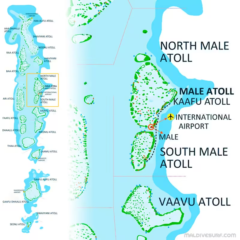
Major Atolls and Their Highlights of Map of Maldives
- Malé Atoll (North & South) – Malé The bustling heart of the Maldives is Malé, the nation’s compact yet vibrant capital. Despite covering just 9.27 square kilometres, Malé is home to a lively population—over 140,000 residents as of 2017—making it one of the world’s densest cities. The capital serves as the cultural, economic, and political hub of the country, with easy access to the rest of the archipelago via Velana International Airport.
Malé: The Vibrant Heart of the Maldives
Malé serves as the bustling capital city of the Maldives, anchoring the nation’s administrative, cultural, and economic life. Despite its compact area of just 9.27 square kilometers, Malé is home to a population of approximately 143,000 residents (as of 2017). This lively urban center blends centuries-old mosques, colorful markets, and modern developments, offering a fascinating contrast to the tranquil islands and atolls that surround it.
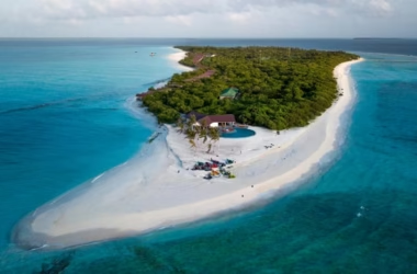
- Baa Atoll – A UNESCO Biosphere Reserve, famous for Hanifaru Bay’s manta ray gatherings.
- Ari Atoll – Known for world-class diving sites and luxurious overwater bungalows.
- Addu Atoll – The southernmost atoll, offering historical sites and a distinct local culture. Spanning the southern tip of the Maldives, Addu Atoll stands out for its unique blend of traditions shaped by centuries of contact with India, Sri Lanka, and the Arab world. Here, you’ll find remnants of British World War IIfacilities, ancient mosques, and a proud local heritage, all set against the backdrop of the atoll’s lush islands. Despite the Maldives’ modest land size—just around 90,000 square kilometers, making it Asia’s smallest country by both land area and population—places like Addu Atoll showcase the nation’s rich cultural and historical tapestry.
- Lhaviyani Atoll – Popular for its stunning sandbanks and high-end resorts.
Each atoll on the Maldives islands map offers something unique, from diving hotspots in the Maldives to secluded private islands ideal for honeymooners
Comparing Atolls: Levels of Development and Tourist Experiences
While the Maldives’ atolls are united by shimmering lagoons and lush coral islands, each one paints its own picture when it comes to development and things to do. Some atolls near the capital, like North Malé and South Malé, are more developed, boasting easy access to international airports and a dazzling collection of world-class resorts perched on private islands. Here, you’re never far from a spa day, elegant dining, or a sunset cruise—all with the city lights of Malé on the horizon.
Venture further afield, and the atmosphere transforms. In places like Baa Atoll—a UNESCO Biosphere Reserve—the focus shifts to eco-adventures and marine conservation. Expect manta ray encounters in Hanifaru Bay, sustainable overwater villas, and fewer crowds. Likewise, Ari Atoll draws divers and snorkelers with its famous underwater sites, but its resorts are often more spread out, making the experience feel exclusive and tranquil.
Some atolls, such as Addu or the far-flung islands in the north and south, remain lightly developed, granting visitors a taste of authentic Maldivian culture. Local guesthouses and smaller hotels dot these regions, and cultural tours, fishing excursions, and island-hopping trips offer a window into daily island life.
In summary:
- Atolls closest to Malé are the most developed, with plentiful luxury resorts and easy access.
- Outer atolls offer quieter retreats, unique cultural insights, and untouched natural beauty—ideal for travelers seeking adventure, biodiversity, or authentic experiences.
- Activities differ by atoll, from the bustling water sports hubs near Malé to the serene, conservation-focused escapes of Baa, or intimate, locally-owned guesthouses farther from the main travel routes.
Popular Tourism Activities in the Maldives
A glance at the Maldives islands map highlights more than postcard-perfect beaches—it’s a playground for adventure seekers and relaxation enthusiasts alike. Most resorts are located on their own private islands, transforming each atoll into a unique destination teeming with possibilities.
- Snorkeling and Diving: The Maldives is world-renowned for vibrant coral reefs and astonishing marine life, rivaling top dive spots globally. Clear waters invite beginners and seasoned divers to swim alongside manta rays, whale sharks, and colorful shoals of fish.
- Water Sports: Kayaking, paddleboarding, jet skiing, and windsurfing are just the start. Calm lagoons make for ideal conditions, and resort teams are always ready to kit you out for an afternoon of aquatic fun.
- Island Hopping: Exploring neighboring islands by traditional dhoni or speedboat reveals untouched sandbanks, tiny fishing villages, and a glimpse into everyday Maldivian life.
- Cultural Experiences: Beyond water-based adventures, many visitors enjoy guided tours of local islands to sample traditional cuisine, visit historic mosques, or learn about Maldivian crafts and culture.
From tranquil days on white-sand beaches to adrenaline-fueled underwater explorations, the Maldives offers an unforgettable mix of leisure and adventure for every traveler.
Activities and Experiences in the Maldives
The Maldives offers a diverse array of activities perfectly suited to its idyllic setting. Adventure-seekers can dive beneath the waves to discover vibrant coral reefs, join guided snorkeling excursions, or set out on unforgettable island-hopping journeys that reveal local life and untouched beaches. The calm, clear lagoons beckon for paddleboarding, kayaking, and windsurfing, while the deep waters attract big game anglers hoping to reel in a trophy catch.
Cultural explorers aren’t left behind—many inhabited islands welcome visitors to experience authentic Maldivian hospitality, sample traditional cuisine, and learn about local artisanship. Whether you’re basking on sun-drenched sandbanks, embarking on dolphin-watching cruises, or exploring the underwater world famed among divers worldwide, there’s no shortage of enriching experiences to choose from in this tropical sanctuary.
Navigating the Map of Maldives: Transportation and Accessibility
A Maldives travel map is essential for planning transportation. The country’s dispersed geography means that getting around requires a mix of air and sea travel.
Key Transportation Methods
- Domestic Flights: Several regional airports connect distant atolls to Malé.
- Seaplanes: Operated by Trans Maldivian Airways, offering scenic aerial views of the Maldives atoll map.
- Speedboats and Ferries: Regular services connect inhabited islands and resorts.
- Private Yachts: A luxurious option for island hopping.
Environmental Considerations and Conservation Efforts
The Maldives map geography highlights the nation’s vulnerability to climate change, with most islands lying just 1-2 meters above sea level.
Conservation Initiatives
- Coral Reef Restoration: Organizations like Reefscapers focus on coral transplantation.
- Eco-Resorts: Many resorts implement sustainable practices to protect marine ecosystems.
- Government Policies: Strict regulations control overfishing and coastal development.
What Makes Each Atoll in the Maldives Unique?
Each atoll in the Maldives weaves its own story, blending natural beauty, local culture, and tailored experiences for every type of traveler. Some atolls are vibrant hubs, buzzing with luxury resorts and amenities designed for vacationers seeking the iconic Maldivian escape—think lavish overwater villas, gourmet dining, and endless watersports. Others remain much quieter, inviting you to step into a more traditional rhythm of island life, with small fishing villages, local markets, and a pace that feels a world away from the everyday.
Distinct personalities emerge as you explore the map:
- Malé Atolls (North & South): These neighbor the capital and host a dazzling array of renowned resorts within easy reach, making them ideal for first-time visitors who want convenience alongside beauty.
- Ari Atoll: A diver’s paradise, celebrated globally for its extraordinary underwater scenes—whale sharks, manta rays, and kaleidoscopic coral gardens all feature heavily here.
- Baa Atoll: Awarded UNESCO Biosphere Reserve status, this atoll is famed for its ecological significance, especially for snorkeling and witnessing manta ray gatherings in Hanifaru Bay.
- Addu Atoll: Down in the south, you’ll find rich history, distinctive cultures shaped by distance, and scenic cycling trails connecting inhabited islands over causeways.
- Lhaviyani Atoll: A favorite for those seeking remote sandbanks, untouched beauty, and ultra-exclusive resorts perfect for honeymoons or quiet retreats.
Whether your heart beats for adrenaline-fueled water sports, slow discovery of local heritage, or simply unwinding beneath swaying palms, the atolls of the Maldives offer a tapestry of experiences—each island cluster with its own flair and memorable charms.
Frequently Asked Questions About the Maldives Map
1. Where are the Maldives located?
The Maldives map places the country in the Indian Ocean, southwest of Sri Lanka and India.
2. How many islands are in the Maldives?
The Maldives consists of 1,190 islands, with about 200 inhabited and 150 developed for tourism.
3. What is the capital of the Maldives?
Malé, located in North Malé Atoll, serves as the capital and economic hub.
4. How do you travel between islands in the Maldives?
Travel options include domestic flights, speedboats, ferries, and seaplanes, depending on the distance and location.
5. What are the best islands to visit in the Maldives?
Popular choices include Baa Atoll for marine life, Ari Atoll for diving, and Addu Atoll for local culture.
6. What languages are spoken in the Maldives?
Dhivehi is the official language across the Maldives, giving the islands a unique linguistic heritage. However, travelers will find that English is widely spoken, especially in resorts, hotels, and other tourist hotspots, making communication easy for most international visitors.


1 thought on “Map of Maldives: A Complete Guide to Atolls, Islands”
Comments are closed.